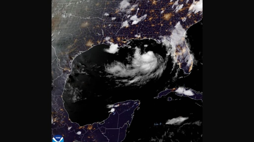
Panama City, Florida: Tropical Storm Bertha has become the second named storm of the 2026 Atlantic hurricane season, and it is bringing the threat of flash flooding, storm surge, and gusty winds to a wide stretch of the northern Gulf Coast this week.
Storm Stalls Near the Coast
As of Monday night, the center of Bertha sat roughly 140 miles south of Panama City and about 215 miles southeast of Mobile, Alabama, according to the National Hurricane Center. The storm had essentially stopped moving, with forecasters describing it as nearly stationary through the evening hours.
Maximum sustained winds were near 40 mph, and meteorologists said some additional strengthening was possible over the following day or so. Forecasters do not expect Bertha to reach hurricane strength, largely because of dry Saharan air and strong wind shear working against it.
AccuWeather’s lead hurricane expert, Alex DaSilva, said dry air and hostile shear across the Gulf will largely determine whether the system organizes any further, though a brief drop in shear could allow faster strengthening and a shift farther west toward Texas.
A slow west-northwestward or westward drift is expected over the next several days, keeping the storm near or along the northern Gulf Coast before it eventually pushes toward Texas later in the week.
Watches and Warnings Span Four States
A tropical storm warning stretches from the Alabama-Florida border west to the Jefferson and Plaquemines parish line in southeastern Louisiana. A tropical storm watch covers the Florida Panhandle from the Bay-Gulf county line to the Alabama border, along with areas west of Jefferson and Plaquemines parishes to Morgan City, Louisiana, including metro New Orleans, Lake Pontchartrain and Lake Maurepas.
A storm surge watch is also in place from the mouth of the Mississippi River to the Alabama-Florida border. Forecasters warned that storm surge combined with high tide could push water two to four feet above ground in parts of Louisiana, Alabama and Florida.
Officials cautioned that an isolated tornado or two could spin up over the Florida Big Bend region as the system moves through.
Beachgoers in Orange Beach, Alabama, were greeted by red flags Monday warning of dangerous surf and rip currents, while emergency officials in Escambia County, Florida, began offering sand for residents in flood-prone neighborhoods to fill sandbags.
Heavy Rainfall Is the Main Threat
Forecasters largely agree that flooding, not wind, poses the greatest danger from Bertha. The National Hurricane Center projected rainfall totals of two to four inches across the Gulf Coast and nearby inland areas, from western Florida to the Texas coast, with isolated spots seeing as much as eight inches.
Southern Alabama, Mississippi, and Louisiana are also included in that rainfall outlook, with flash flooding most likely in urban areas through Thursday or Friday.
Dr. Ryan Truchelut of WeatherTiger noted that under any realistic scenario, Bertha would mainly function as a rainmaker, since northerly shear is keeping much of the storm’s thunderstorm activity out over open water. He expects periodic rain bands to move across inland North Florida over the next couple of days before expanding into the western Panhandle and eastern Louisiana.
DaSilva added that while the rain could offer some relief to drought conditions in the Florida Panhandle, dry and hardened soil in the region may actually worsen runoff and flooding risk rather than absorb the moisture. He also flagged concern that if heavy rain shifts farther west into the Texas Hill Country, the area’s terrain and its history of severe flooding could raise the danger level further.
A Quiet Season So Far, but Forecasters Urge Caution
Bertha follows Tropical Storm Arthur, which soaked the southeastern United States in June as the season’s first named storm. Federal forecasters have called for a below-normal season overall in 2026, pointing to El Niño as a key factor suppressing storm development.
NOAA’s seasonal outlook calls for eight to 14 named storms, with three to six expected to become hurricanes, below the 1991 to 2020 average of 14 named storms and seven hurricanes.
Even so, hurricane specialists continue to stress that storm counts do not guarantee safety. A single landfalling storm can still cause major damage regardless of how active or quiet the wider season turns out to be, and officials are urging Gulf Coast residents to keep monitoring updates as Bertha’s exact path becomes clearer over the coming days.