Phoenix, Arizona, is bracing for a stretch of dangerous heat just as the tail end of a stormy pattern moves through the state this week.
Storms Move Through Before The Heat Arrives
Heavy thunderstorms tracked west and southwest across Arizona Monday evening, bringing torrential rain, flash flooding and hail as large as half-dollars in some areas. The High Country saw the worst of it, with flash flood warnings posted as storms dumped heavy rain on already saturated ground.
Prescott Valley took a direct hit from an intense monsoon cell that brought damaging winds along with the rain and hail, leaving residents to deal with cleanup and lingering high water once the storm passed.
The Valley itself saw storms arrive late Monday night, bringing the potential for blowing dust, damaging wind gusts, and localized flooding. Rain looked likely to continue into the early Tuesday commute before tapering off. Temperatures dropped to around 85 degrees overnight as the storms rolled through.
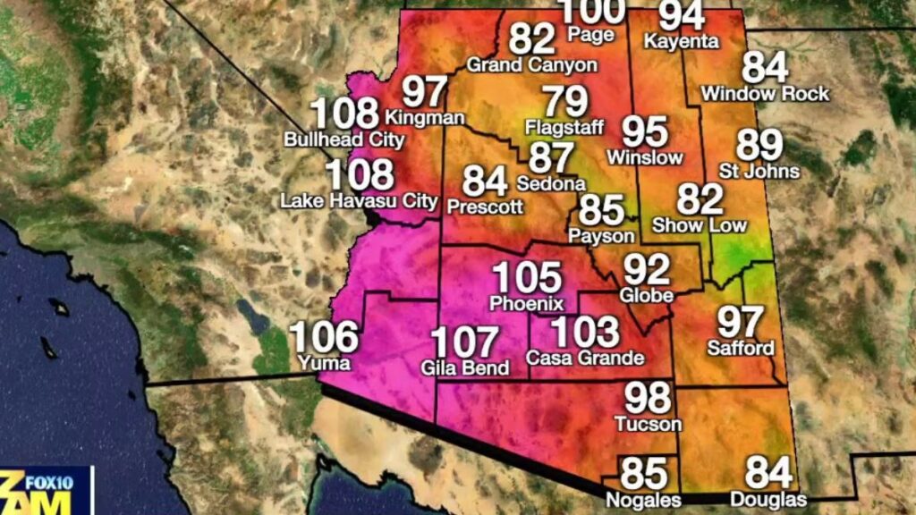
Tuesday is expected to be mostly cloudy and largely dry across the Phoenix metro, with highs near 103 degrees. Storms will keep firing up in the mountains and High Country during the afternoon, but forecasters don’t expect the Valley to see rain again until late Tuesday night at the earliest.
A flood watch remains in effect through Tuesday evening for much of northern and southeastern Arizona, including Flagstaff, Payson and Globe, where an additional 1 to 2 inches of rain could fall on ground that’s already soaked, raising the risk of flash flooding along rivers, creeks and washes.
Flagstaff Already Ahead Of Normal Monsoon Totals
The monsoon season has been especially generous in northern Arizona so far. Flagstaff has collected 2.74 inches of rain since June 15, well above the typical monsoon-to-date average of 1.47 inches.
Isolated storms are expected to continue across the High Country through midweek before becoming more scattered by Thursday and Friday, as the pattern shifts and drier air works its way back into the state.
Wednesday should bring a bit of a rebound in temperatures, with highs climbing to around 108 degrees in the Valley and only a slight chance of an afternoon shower lingering from the departing system.
Extreme Heat Watch Set To Take Over Late Week
Once the storms clear out, attention turns quickly to the heat. An extreme heat watch goes into effect Thursday and lasts through Monday for southwestern Arizona, covering the entire Phoenix metro area along with Pinal County, Yuma County and the surrounding desert regions. Highs are expected to climb into the 110 to 114 degree range, with those days officially designated First Alert Weather Days because of the danger involved.
Anyone planning to spend time outdoors is urged to avoid prolonged sun exposure between 10 a.m. and 6 p.m., drink water consistently, and take breaks in shade or air conditioning whenever possible. Heat-related illness can escalate fast in these conditions, ranging from cramps and exhaustion to heat stroke, which can bring confusion, hot and dry skin, a rapid weak pulse, and in severe cases seizures or unconsciousness.
Anyone showing signs of heat stroke needs immediate medical attention, and residents are encouraged to check on older neighbors, family members, and anyone without reliable air conditioning at least twice a day during the watch period.
Local officials are also reminding residents to prepare for both hazards this week. That means having water and supplies ready in case of flooding or power interruptions, while also treating the coming heat wave seriously by limiting outdoor activity during peak afternoon hours and staying hydrated well before heading outside.
With flooding risk fading and extreme heat moving in right behind it, Arizona is heading into a week that demands caution on two very different fronts.